1. (a) Identify any two adjoined map sheets to the area covered by the map
(b) (i) Give two features of the map which shows that the area to the south east of the area
covered by the map receives high amount of rainfall(cite evidence)
(ii) Name two physical features found in grid square 4548
(c) (i) Reduce by a half the area covered by easting 23 to 30 and northing 47 to 53
(ii) On the reduced area mark and label the following:-
All weather road loose surface
District boundary
(d) (i) Describe the drainage of the area covered by the map to the south of northing 50
(ii) Citing evidence from the map give three economic activities carried out in the area
covered by the map
2. (a) (ii) What is the latitudinal and longitudinal location of shopping centre at grid square 5863
(ii) Name the continuous man made feature along Road B1
(b) (i) Apart from spot height, give two other methods which have been used to show
relief on the map
(ii) Measure the length of the road D313 between Northing 68 and Northing 70.
Give your answer in kilometers
(iii) Calculate the bearing of the culvert in grid square 6066 from river confluence in
grid square 6269
3. (a) (i) Draw a cross-section along Easting 67 from Northing 67 to Northing 71.
(Use a vertical scale of 1cm rep. 80m)
On the cross section you have drawn, mark and name:
– Hill
– Pass
– Road D313
(ii) Calculate the vertical exaggeration of the cross section you have drawn
4. Study the map of Belgut 1:50,000 (sheet 117/3) provided and answer the following questions
a)i)Give the general direction of the flow of river Itare
ii) What is the bearing of a trigonometrical station 117S 13 at grid reference 443512 from
a tea nursery found at grid reference 443447?
iii) Name two types of trigonometrical station that have been used to show the relief in
the area covered by the map
iv) Calculate the area that s found on the western side of river Sondo. Give answers in meters
b)i) Using a vertical scale of 1cm to represent 100 meters draw a cross-section from grid
reference 260520 to grid reference 340520
ii) On the cross-section, mark and label the following
- A hill
- A provincial boundary
- All weather road, loose surface
- Riverine trees
iii) Calculate the vertical exaggeration of the cross-section
c) Students from Chemamul School set out to carry out field work in the area of Belgut
i) With evidence, name two crops they found being grown in the area
Use the diagram below to answer questions 5
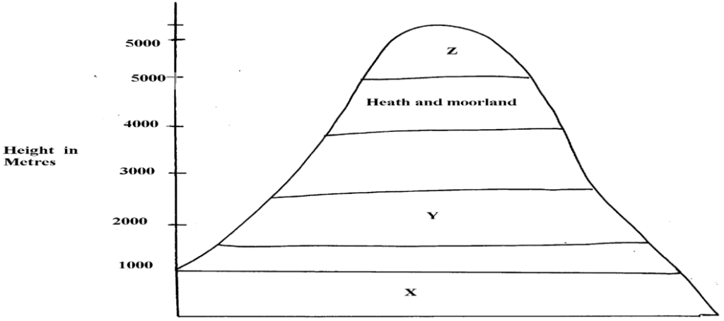
5. (a) Name the vegetation types marked X and Y
(b) Give two reasons for the absence of vegetation at Z
(c) Name any one part in Kenya represented by this diagram
6. Use the map of Kericho (1:50,000) to answer the questions
Study the map of Belgut 1: 50000 (sheet 117/3) provided and answer the following questions
. (a) (i) What is the height of the highest contour in the area covered by the map?
(ii) Give the longitudinal extent of the area covered by the map.
(iii) Calculate the area of the part of Kisii district shown on the map.
(iv) What is the six figure grid reference of the junction at Marumbasi?
(b) (i) Draw a rectangle 10cm by 14cm to represent the area between easting 30 and 40
(ii) On the rectangle mark and name the following:-
– A plantation
– River Yurith
– A seasonal swamp
– The bridge at Kabirigut
(iii) Calculate the new scale of your reduction
(c) Describe three ways in which physical factors have influenced the construction of all
weather roads in the area.
(d) (i) Citing evidence from the map, explain three factors that favour the growing of tea in Belgut.
(ii) With evidence from the map name any other crop grown in the area other than tea.
7. Study the map of Belgut: 1:50000 (sheet 117/3) provided and answer the following questions
. a) i) Convert the scale of the map into statement scale
ii) Give the longitudinal extend of the area covered by the map
iii) Calculate the bearing of the posho mill at Kiptule from the spot height at Kiptere
b) Apart from forests name other vegetation types in the area covered by the map
c)i) Draw a rectangle measuring 15cm by 8cm o represent the area south of northing 50 and
West of easting 30. On the rectangle mark
- River Sondo
- Coffee mill
- All weather road loose surface
- Wood land
ii) Describe the drainage of the area covered by the map
d) What factors on the map can promote trading activity
8. Study the topographic map of Belgut provided and use it to answer this question
(a) (i) Name the two provinces covered in the area by the map
(ii) What is the general direction of Ikamu school from Chemamul school?
(iii) Write the six figure grid reference of the Posho Mill at Kiptule
(b) (i) Measure the distance of all weather road (bound surface) from Kapsuser shops to
its ends in the North-East to Kericho. Give your answer in Kilometers
(ii) Identify two methods used in the map to locate places
(iii) Name three types of natural vegetation found in the area
(iv) Citing evidence from the map, name three agricultural activities carried out in Belgut area
(c) Citing evidence from the map, explain three physical factors which have influenced
settlement in the area
(d) Describe the drainage of the area covered y the map
9. a i) What type of map is Belgut sheet?
ii) Give two methods used in representing relief on the map extract.
b i) What is the length of the Murram road from Marumbasi to Kiptere Sunchen
(Give your answer in Km)
ii) Name the main crop planted under plantation from the map
c i) Explain how relief has influenced settlement in the area covered by the Map
ii) Citing evidence from the map, give two social – economic activities carried out in the
area covered by the map.
d i) Using a vertical scale of 1 cm to represent 100 metres, draw a cross section from the
East 440000 to easting 500000 on the cross section label:
– Road
– River
– Forest
10. Study the map of BELGUT 1:50,000 provided and answer the following questions
a)i) Give the longitudinal extent of the area covered by the map
ii) Convert the scale of the map into a statement scale
iii) Name two methods that have been used to represent relief on the map
b) i) Draw a cross-section between grid references 29050 and 33050. Use scale of 1cm
to represent 20 meters
ii) On the cross-section Mark and name:.
– papyrus swamp
– All weather road loose surface
iii) Calculate the vertical exaggeration
11. a) Describe the drainage of the area covered by the map
b) Citing evidence from the map, give three economic activities carried out in the area
covered by the map
c) State two functions of the tea factory to the population around.
d) Give three reasons to show the area covered in the map receives high rainfall. The evidence
should be deducted from the map
12. Study the map of Belgut 1:50,000(sheet 117/3) provided and answer the following questions
(a) (i) What type of a map is Belgut ?
(ii) Give the grid square in which Matongo school is found
(iii) Calculate the area enclosed by Kendu-Kisii, all weather roads (bound surface) to
the West of the map
(iv) Citing evidence from the map, identify four social activities taking place in the map
(b) (i) Draw a cross-section along Northings 54 between Eastings 26 to 32. Use vertical scale of
1cm to represent 20m. On it mark and name:-
(I) River
(II) Loose surface road
(III) Swamp
(ii) Calculate the vertical exaggeration
(c) Describe the drainage of the area covered by the map
(d) Citing evidence from the map, explain two conditions that favour cattle rearing in the
area covered by the map
13. Study the map of Kericho (1:50,000) sheet 117/4 provided and answer the following questions
(a) i) What is the bearing of the secondary trigometrica station 2173 around Kapcheptoror
school form the dry weather road junction at Kipchimchim school
(ii) Give a six-figure grid reference of the trigometrical station (other) 1811 near
Poiywek school
(iii) Convert the scale of the map into a statement scale
(iv) Using liens of latitudes and longitudes give the position of Keongo school at gird
square 5662
(v) Give two methods used in representing relief in the are covered by the map
(b) Citing evidence from the map, state:-
(i) Two social functions of Kericho Municipality
(ii) Two economic activities carried out in the area covered by the map
(c) Using a vertical scale 1cm represents 20m
(i) Draw a cross section form grid reference 550640 to 590660
(ii) On the cross-section, mark and name the following:-
- A river
- Dry weather road
- A hill
(d) Describe the drainage of the are covered by the map
14. Study the map of Belgut (117/3) provided and answer the questions that follow:
(a) Identify two provinces covered by the map of Belgut
(b) (i)Using a vertical scale 1cm represents 50m, draw a cross section from grid reference
260590 to 330560. on it mark and name;
- All weather loose surface roads
- Marshes
- River
(ii) Calculate the vertical exaggeration of the cross section.
(iii) What type of map is Belgut?
15. Study the map of BELGUT (1:50000 sheet 117/3) providedand answer the questions below:
a)i) Give the six figure grid references of the confluence of the river Itare and river Kitoi.
ii) Measure the length in kilometers of all weather roads loose surface from the junction
at grid square 3957 to the junction at Kipmaso grid square 3751.
iii) Give the name to the adjoining sheet found in the North East of Belgut .
b) i) What is the longitudinal extent of the area covered by the map?
ii) What is the approximate height of the school at kiptere grid square 3658?
c) i) Describe the drainage of the area covered by the map.
ii) Using a vertical scale of 1cm to represent 40 metres draw a cross-section along northing
53 from easting 24 to 29.
On it mark and name
– regional boundary
– Foot path
– main track (motorable)
d) i) Describe the distribution of the settlement of the area covered by the map.
ii) Citing evidence from the map, explain two factors that may favour trading activities
in the area covered by the map.