1. a) Composite volcano
b)i)What are earthquakes?
ii) Name two types of earthquakes waves
iii) Explain three ways in which volcanic mountains positively influence human activities
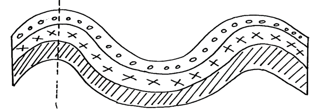
2. a) Using well labeled diagrams, distinguish between a simple symmetrical fold and an
asymmetrical fold.
b) i) Name two fold mountains of the Alpine Orogeny
ii) With the aid of well labeled diagrams, describe how a fold mountain is formed.
c) Explain three positive effects of folding on the physical & human environment.
3. (a) State three ways in which the earth’s crust is affected by the earthquakes
(b) State two evidences of continental drift theory
(c) Name three types of plate tectonic boundaries
4. (a) (i) What are tectonic plates
(ii) Give any two examples of oceanic plates:-
(b) Describe how the following cause earth movements:
(i) Isostatic adjustment
(ii) Magma movement in the crust
(iii) Convectional currents in the mantle.
5. (a) Give any two natural causes of earthquakes
(b) Name three characteristics of the rift valley lakes of Kenya
6. (a) State three characteristics of the rift valley lakes of Kenya
(b)(i) What are earth quakes?
(ii)Name three types of earth quake waves
c). Differentiate between extension boundaries and compression boundaries.
7 a. i) What is an earthquake
ii) Give two ways in which earthquakes can be predicted
b) State two ways in which faulting interferes with transport and communication lines.
8. The diagram below represents a feature resulting form faulting
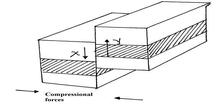
(a) Name the feature
(b) Name part x and y
(c) Give three negative of an earthquake
9. (a) Differentiate between hot springs and geysers
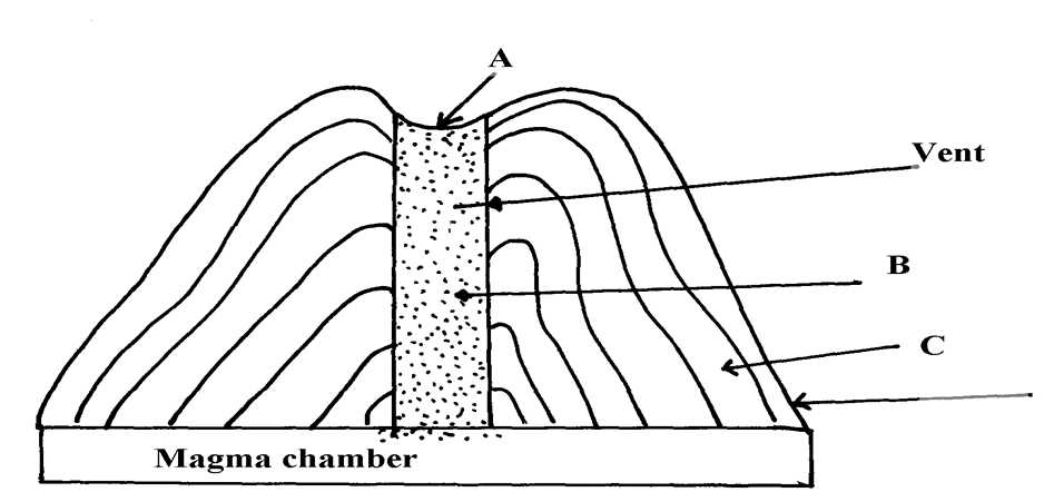
(b) The feature below show an extrusive landform in a volcanic area
(c) Using well labelled diagrams, describe how the following are formed:
(i) An anticlinal fault
(ii) An overthrust fold
(d) (i) Explain any three ways in which features resulting from volcanicity are a problem
to people
(ii) Describe how subsidence can lead to formation of a caldera.
10. (a) What is the plate tectonic theory ?
(b) Name three types of tectonic plate boundaries .
(c) Explain two evidences that support continental drift theory.
11. (a) (i) Name two fold mountains in Africa apart from Atlas mountains
(ii) Differentiate between symmetrical and asymmetrical folds
(iii) Apart from symmetrical and asymmetrical folds, name other types of folds
(b) (i) With the aid of well labeled diagrams explain the formation of fold mountains
(ii) Give two-examples of fold mountains in North America
12. a) Effects of the elliptical shape of the earths orbit
b) Mention three causes of the earth movements
13. a) List two characteristics of destructive plate boundary
b) Outline three natural causes of earthquakes
b) State two effects of earthquakes on crystal rocks
14. a) List two factors that determine the degree of folding in rocks
b) State three effects of faulting on drainage systems
15. (a) State any one evidence that support the theory of the drifting of continents
(b)(i) Apart from Africa, name any two other continents that form the Gondwanaland
(ii) What is panthalassa?
16. a) Give two reasons why hardwood trees species in Kenya are in danger of extraction
b) State three problems that affect forestry in Canada
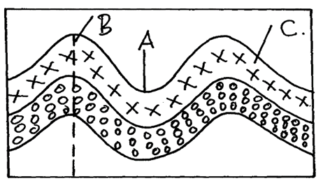
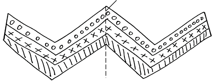
17. The diagram below shows a simple fold
(a) (i) Name the part marked A, B and C
ii) Name two fold mountains outside Africa
(iii) Give thee landform associated with folded regions
(b) With the aid of well labeled diagram describe the process of formation of Fold Mountain
(c) Explain four ways in which folding influences human activities
ANSWERS FOR THE TOPIC INTERNAL LAND-FORMING PROCESSES IN GEOGRAPHY
1. a) – it has vertical vent/pipe
- compose of alternating layers of ash/pyrodast and lava
- it is conical in shape /steep sided
- it has side vents
- it has conelets/parasitic cones on the sides
- at the peak, it may have a caldera /crater/plug
b i) Earth quakes are sudden earth movement which cause vibrations/trembling within the crust√√
ii) – primary/push/p-waves s
– secondary/shear waves/shake waves/s-waves
– longitudinal/L-waves/lore waves/Raleigh waves
iii) – volcanic mountains re sources of rivers which provide water for
domestic/agricultural/industrial use
- volcanic mountains have forests which provide valuable timber used in building and construction industries
- volcanic mountains influence formation of relief rainfall which encourages agricultural activities
- volcanic mountains modify temperatures making them attractive to human settlements
2a.
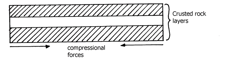
- Formed when compressional forces of equal magnitude and of moderate strength act on crustal rocks
- The rocks bend evenly and the anticline is symmetrical about its axis
- Results from unequal compressional forces acting on crustal rocks
- One of the forces is slightly stronger than the other resulting to limbs that are assymetrical about the axis
b i) – Atlas mountains of Africa
– Alps mountains of Europe
– Himalayas mountain of Asia
– Rockies of N. America
– Andes of S. America
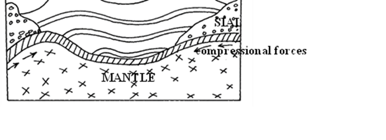
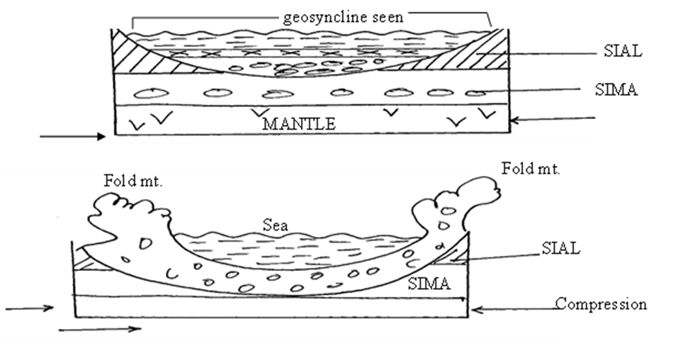
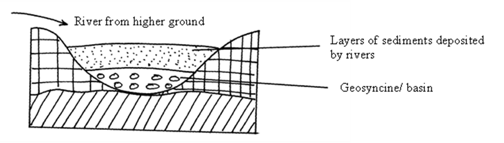
b ii) – An extensive depression called a geosynclines is formed on the surface of the earth – The geosynclines is then filled with water to form a sea
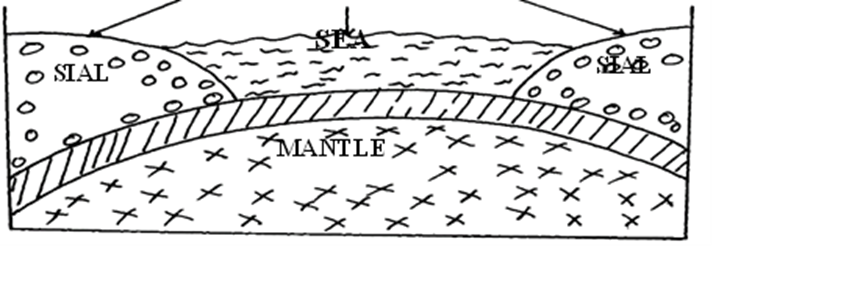
- The surrounding land masses are eroded and resultant materials deposited in the geosyncline in layers
- Accumulation and weight of sediments causes the floor of the geosycline to subside further
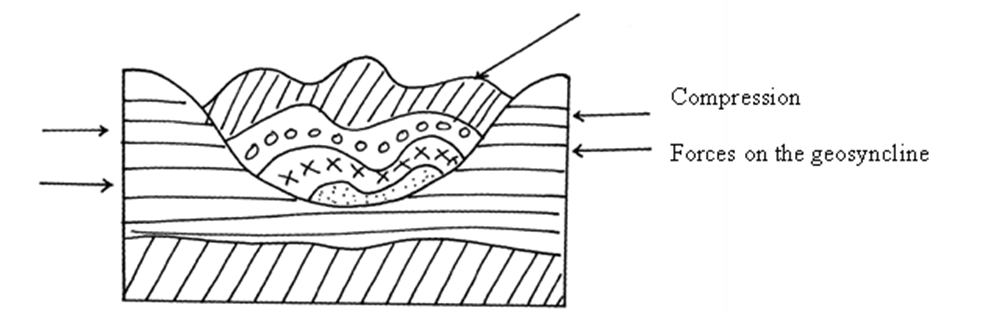
- Further subsidence of the geosynclines triggers off compressional forces drawing higher grounds close
- The layers of sediment in the geosynclines are the folded bending upwards form mountains
c) – Fold mountains are often forested on their windward slopes and provide valuable
timber for construction
– The windward slopes receive rainfall hence supports agriculture
– Heavy rainfall and snow that collects in some fold mountains give rise to rivers which
in turn provide water for both domestic &industrial use
– The process of folding could bring valuable minerals to the surface cutting down the
cost of mining e.g. coal in Appalaction
– The unique mountains landscape attracts tourist thus earning the country foreign
exchange
3. a) – earthquakes causes lateral and vertical displacement of rocks
- they cause raising and lowering and down warping of parts of the sea floor
- it causes landslides/slumping
- it leads to faulting of the c rust
- they lead to volcanic eruptions
b) – The jig saw fit of continental magins e.g. Southern Africa and Southern America
– Spreading of the ocean floor- rocks are younger at the oceanic trenches and younger
outwards
– Geological evidence i.e. the rock structure in some continents are similar e.g. South Africa and South America meaning that they were together
– Palaeoclimatic evidence, similar fossils/ remains have been found in different continents
c) – Extension boundary/ divergence
- Comprisin/ convergence
- Transform fault boundary
- Conservative boundary
4. a i) Tectonic plates are seirigid blocks that form the earth’s crust
ii) – Pacific plate
– Nazca plate
. b i) This disrupts the balance between the sial and sima causing movement of continental
masses
ii) This force themselves in cracks/crevices displacing crustal rocks
iii) These cause frictional drug/pull on the crustal rocks causing their movement
5. a) -Isostatic adjustments
-Gravitation pressure
-Tectonic movement
-Magma movement (volcanic activities)
-Energy release in upper mantle
. b) -primary (P) waves
-secondary (S) waves
-surface longitudinal waves
6. a) -they are long deep and narrow
-most of them are salty
-they are fault lakes
b)i) -They are sudden earth movement which cause trembling/vibration within the earth’s
crust.
(ii) – Primary/ puse waves/p. waves.
– Secondary/shear/S. waves
– Longitudinal/love/L. waves
c ) Extension boundaries are zones where tectonic planets diverge or move away from
each other. Space may be created and magma fill the space found in between. While
compress ional boundaries are zones where tectonic plates moves towards each other.
There is thus destruction of materials found at the edges
7. a i) – Is a sudden and rapid movement/tremor of the earth crust.
ii)- Use of change of velocity of seismic waves
– Use of exotic pre-quake signals.
b) – Faulting causes disjointing of the land which results in disruption of transport and
communication lines.
– The presence of fault scarps can cause difficulty in construction of transport and
communication lines.
– It is expensive to construct and communication lines in faulted region.
8. a) reverse fault
b) X-up throw
Y-down throw
. c) – Fire outbreaks
-destruction of transport and communication lines
-loss if life and properties/collapse of buildings
– Change directions of rivers flow
9. a) -hot springs are place where hot water or steam is emitted from the ground while
geysers are jep of hot water or steam and gasses which are ejected explosively
from fissure in the ground
b) A-crates B-plug C-strato volcano
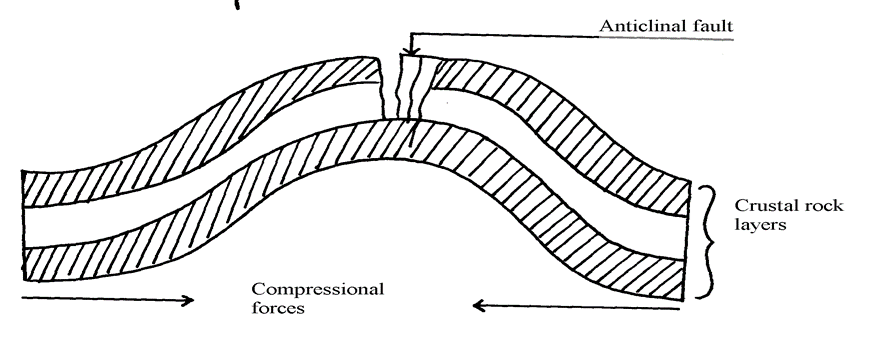
c) i) – Crustal rock layers are subjected to compressional forces
– This leads to formation of a massive article /up fold
– Further compression to the same crustal rocks causes stress/tension at the crest of the anticline
– Eventually a crack/fault and around the crust of the anticline called an anticline fault
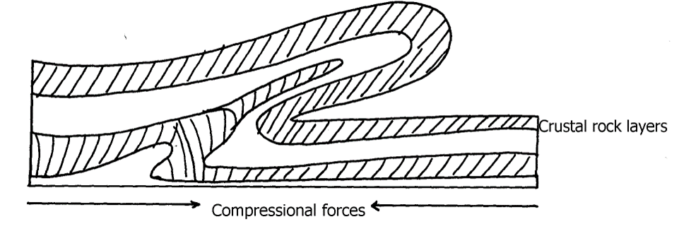
c ii) – Crustal rock layers are subjected to compressional forces
– Intense folding results into formation of an overfold
– With increased pressure the over fold is compressed further to form a recumbent fold
– When pressure if very great, a fracture occurs along the axis producing a thrust plane
to form an overthrust fold
d i) – Volcanic mountains experience low rainfall on their leeward slopes making them
unsuitable for agriculture/settlement/forestry
– Volcanic mountains have steep slopes which hinder transport and communication
– Some volcanic features like moffetes, solfataras steam jets produce poisonous which
pollute the environment/are harmful to people
– Some volcanic rock weather to form infertile solid unsuitable for agriculture/forestry
d ii) – Outpouring of Lava forms a volcanic cone
– When the pressure beneath stops, a hollow, void is left beneath
– The weight of the overlying cone leads to collapse of the top of the cone into the how-
/void beneath
– This leaves a wide depression at the top of the volcano called a caldera
10. a) – It is a theory that states that the crust is divided into blocks of land (plates) that
float and move towards, away or parallel
b) – Compressional boundary
- Extension boundary
- Transform fault boundary
c) – Geological evidence – Rock similarities in structure, age and type of rocks found in
various continents e.g. in Eastern coast of S. America and Western coast of Africa
- Jig- saw- fit – of continental coastlines. Some coastlines can fit each other when pulled together e.g. Western coast of Africa can fit with Eastern coast of South America
- Ancient glaciations – All the four Southern continents reveal signs of a period of large scale glaciations at one time. It is evidenced by presence of glacial deposits – Tillites produced by ice sheets in Southern continents
- Archeological evidence – Some plant and animal remains found in various continents show a striking similarity
11. a i) – Atlas
– Cape ranges
– Akwapim
ii) – Atlas
– Cape ranges
– Akwapim
iii)- Symmetrical folds have limbs dipping uniformly about the axis while asymmetrical fold one limb is steeper than the other about the axis
b i) – Extensive shallow depression called geosynclinal develop
– Sediments from high areas are deposited in the geosyncline
– Compression on either side push towards geosyncline
– Sediments compress to form fold mountains which rise above sea level to form fold
mountains
b ii) – Over fold
– Recumbent folds
– Nappe or overthrust fold
– Anticlinical/ synclinal fold
– Isoclinal
12. a) – Causes seasons
– Varying lengths of day and night time
– Changes in the position of the mid-day sun at different times of the year
– Causes eclipses
b) – Movement of magma within the crust
– Gravitational force towards the center of the earth
– Convectional currents in the mantle
– Isostatic adjustment of sial and sima layer
13. a) – Frequent earthquakes
– Presence of faults
– Presence of fold mountains
b) – Tectonic movements
– Volcanicity
– Gravitative pressure
– Isostatic adjustment
– Energy release in the mantle
14. a) – Nature and age of the rocks
– Intensity of compression forces
. b) – May cause a river to disappear
– Changes the rivers direction of flow
– Forms depressions hat are filled with water forming lakes
– Faulting across a river forms waterfalls
15. a) – The jig-saw fit√
– Glaciatean/ancient glaciation√
– The coal deposits√
– Sea floor spreading√
b i) – Australia√
– South Africa√
ii) this was the water body that occupied the region surrounding the pangae
16. a) – High demand for hard wood has led to over exploitation
- They take long to mature hence can not match the exploitation rate
- Population pressure has led to cutting trees to give room for settlement and agriculture
b) – Accidental fires which destroy the forests
- The Northern part is inaccessible (during winter) for exploitation of the forests
- Over exploitation in some areas
- Trees take long to mature due to cold climate
- Rugged landscape especially mountainous landscape makes exploitation difficult
17. (a) i) A-axis B-syncline C-limb of a fold
ii) – The rockets
- Andes
- Himalayas
- Alps
- Appalachians
iii) – fold mountain
- cuesta
- escarpment
- plateus
- basins
b) – Geosynclines are formed on the earths surface
– prolonged and extensive erosion occurs on the surrounding higher grounds
– sediments are deposited in the geosyncline forming thick layers
– the weight of the sediments causes subsistence of the geosyncline leading to
accumulation of more sediments
– further subsidence of the geosyncline triggers off compressional forces which draw the
higher grounds closet forming fold mountains
c) – Fold Mountains are water catchments area. They brap rainfall which rivers which that
provide water for domestics use
– fold mountains are often forested and provide valuable timber used in construction
and building industry(due to high rainfall)
– some fold mountains have valuable mineral deposits such as coal and petroleum for mining
– fold mountains influence transport system enter as barriers or as passed