1. (a) Name two rivers in Kenya West of the Rift Valley that cause frequent flooding
(b) State three factors that lead to frequent flooding in the Lake region of Kenya
2. (a) i) Other than seif dunes, name two other types of sand dunes
ii) Give five characteristics of seif dunes
iii) State four factors that facilitate the formation of the sand dunes
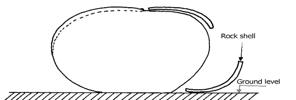
b) Describe how a desert rock pedestal is formed
c) Explain four positive effects of desert features to human activities
3. a) i)Give three reasons why there are no ice sheets in Kenya
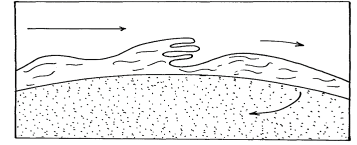
ii) Explain three factors that influence the movement of ice from the place of accumulation
b) Describe the process through which the following features are formed.
i)an arête
ii) A crag and tail
c) Explain four positive effects of glaciation in lowland areas
4. a)i) Give the dates in a year during which the number of hours of darkness is equal in
both the north and the south poles
ii) Why do the lengths of days and nights vary from one part of the earth to another?
b) State two effects of the rotation of the earth on its axis
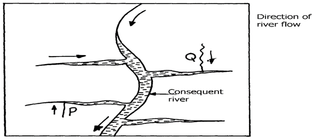
5. a)What is a lake ?
b) State three ways through which lakes are formed
6. a) i) What is desertification
ii) Differentiate between wind deflation and wind abrasion
iii) Describe how wind transports its materials through the following processes:
I) Saltation
II) Suspension
III) Surface creep
b) Describe how the following features are formed
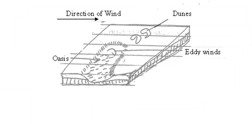
i) Zeugens
ii) Oasis
7. a) State two ways in which glacier moves
b) State three differences between a young river valley and a glaciated valley
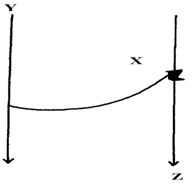
8. The diagram below represents the action of waves on the coastline. Use it to answer
questions (a) and (b)
a) Name the features marked X and Y.
b) List three ways in which waves erode the coastline.
9. Name two sources of underground water.
10. a)i) What is chemical weathering
ii) State five factors that affect the rate of chemical weathering in equatorial regions
b) Explain the following chemical weathering process
i) Carbonation
ii) Hydrolysis
c) Explain four economic importance of weathering to physical and human environments
11. a) Name two types of tides
b) Give three ways in which the shape of the landmasses may influence movement of ocean
waters
(c) State four sources of underground of water
(d) State five ways in which springs occur
(e) Account for four ways in which desert vegetation adopt to the climate of their environment
12. (a) Hamada and Erg
(b) Explain three processes of wind erosion
(c) With the aid of well labeled diagrams, describe the formation of:
i) ABarchan
(ii) Rock pedestal
(iii) An oasis
(d) Name three features resulting from water deposition in desert
13. State three reasons why wind erosion is predominant in desert areas.
(b) Describe three processes by which wind erodes.
(c) With aid of well labeled diagrams, describe the formation of the following desert features;
(i) Rock pedestal.
(ii) Zeugen.
(d) State four ways in which desert land forms influence man’s activities.
14. (a) Differentiate between oceans and seas.
(b) Explain three sources of salinity in the oceans .
(c) State three features on the ocean floor.
15. (a)(i) What is the difference between a sea and an ocean?
(ii) Explain any three ways in which islands are formed.
(b) (i) Describe how Lake Victoria was formed.
(ii) Explain any three ways in which Lake Victoria has influenced the climate of
surrounding areas
(c) (i) Distinguish between aridity and desertification
(ii) Explain any three physical causes of aridity and desertification
16. (a) (i) What is chemical weathering?
(ii) Name any three surface features that result from carbonation.
(b) The diagram below shows a feature resulting from weathering. Use it to answer the
questions that follow:-
(i) What is the name of the feature?
(ii) Describe how the feature is formed.
17. (a) Differentiate between a river system and a river regime.
(b) The diagram below shows a drainage pattern. Use it to answer the questions that follow:-
(i) Name the drainage pattern.
(ii) Name the parts labelled P and Q
18. (a) Name any two features deposited by glacier in lowland areas.
(b) Describe how a roche moutonee is formed.
19. (a) The diagram below shows zones of underground water. Use it to answer the questions
that follow:-

(i) Name the parts labelled U and V.
(ii) Name the surface water feature likely to form at the part labelled W.
(b) Explain how the nature of underground rocks influences the existence of underground water
20. (a) (i) State two ways in which wind erodes the surface of the earth
(ii) Explain three ways thorough which wind transports its load
(b) Using well labeled diagrams, describe how the following desert features re formed:-
(i) Zeugen
(ii) Rock pedestal
(c)(i) Give the name given to rocky desert in the Sahara
(ii) Explain three positive effects of desert features to both human and physical environment
21. (a) What is a lake?
(b) (i) Name two types of lakes formed due to vulcanicity
ii) explaining how lake Victoria has influence the climate of the surrounding area
(c) (i) State four main reasons why lakes within the Rift valley are salty
(ii) Name any three fresh water lakes in Kenya which are within the rift valley
(d) Explain any four economic significance of lakes to Human activities
22. (a) Name three types of tides
(b) Differentiate between oceans and seas
23. (a) (i) Differentiate between aridity and desertification
(ii) Describe three ways through which wind erodes the desert areas
(b) Using well labelled diagrams describe how the following desert features are formed:
(i) Rock pedestals
(ii) Yardangs
(c) State five uses of desert features
24. (a) State four factors which may cause a waterfall to form
(b) (i) Describe how river braids are formed
(ii) Name three features resulting form river rejuvenation
(c) Describe how a river capture occurs
(d) Give two reasons as to why Lake Naivasha is a fresh water lake
25 . Give three ways through which rocks may be metamorphosed
26. (a) (i)State two processes though which the wind erodes the surface.
(ii) Explain three ways though which wind transport its load
(b) Describe how the following desert features are formed :
(i) Oasis
(ii) Zeugen
(c) Explain four ways in which desert land forms are of significance to human activities
27. (a) (i)Name two ways in which ice moves
(ii) State two factors which facilitate the movement of ice
(b) Identify two erosional features in glaciated lowlands
(c) Describe how the following features are formed:
(i) Outwash plain
(ii) Moraine-dammed lake
(d) Explain four ways in which a glaciated landscape is of significance to human activities
28. (a) Differentiate between mechanical and chemical weathering
(b) State three factors which influence weathering
29. a) Differentiate between a spring and well.
b) With aid of a well labeled diagram, show the three Zones of ground water.
c) List four candidates necessary for the formation of an artesian well.
d) Explain three ways in which ground water is of significant to human activities.
e) i) Define the term Karet scenery
ii) Give two conditions for the development of Karet landscape
iii) Outline the significance of Karet landscape to human activities. 30. (a) Use the diagram below to answer the following questions
(i) Name the parts labelled :-
(ii) State four causes of river rejuvenation
31. a i) Differentiate between denudation and mass wasting.
ii) Explain two reasons why chemical weathering is dominant in humid tropics.
b) Explain three factors that influence mass wasting.
c) With aid of a diagram, explain the process of solfluxion.
d) i) State four negative effects of mass wasting.
Name the: Type of mass movement shown
iii) Features M and N
iv) State the factor that influenced the process above
32 a) State three reasons why wind is a major agent of land sculpture in the desert.
b) Explain any two processes of wind erosion in deserts.
c) With and of well labeled diagram, explain how a deflation hollow is formed.
d) State four characteristics of a seif dune.
33. a) State two causes of coastal submergence.
b) Name three conditions necessary for the growth of coral polyps.
34 a) State two ways in which wind transport it’s load
b) Highlight the factors that influence the formation of a desert sand dune
35. a) Name three sources of lake water.
b) State three factors that determine the size of a lake.
36. a) i) What is a river?
ii) Distinguish between a river confluence and a river tributary
b) Describe how a river erodes its channel by the following processes
i) Hydraulic action
ii) Abrasion
37. a) Describe the process of a river capture
b)State five characteristics of a flood plain
38. a) i) Name four features resulting from water action in deserts
ii) State three factors which contribute to the development of deserts
iii) Name three types of deserts according to the nature of their surfaces
b) i)Explain three factors which influence wind transportation in deserts
ii) How is an oasis formed?
39. (a) What is the difference between swash and backwash
(b) Why is wave cut platform and cliff line in Mombasa found above the sea level?
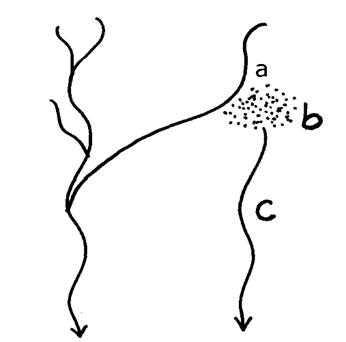
40. (a) Define the term river capture (b) The diagram below shows a river capture, name the features marked X, Y, Z
41. (a) Differentiate between accordant and discordant drainage systems
(b) State three factors that facilitate formation of deltas
42. a) i) What is a desert
ii) Name three types of desert landscapes
b) i) Name two processes of wind erosion responsible for sculpturing desert landscapes
ii) Using well labeled diagrams describe how a zeugen may be formed
c) i) Name four desert landforms found in deserts associated with the action of water
ii) What is the significance of desert landforms
43. (a) (i)Name three processes of wind erosion in desert
(ii) State three factors which influence the rate of wind transportation
(b) With the help of a well labeled diagram describe the formation of the following features:-
(i) Rock pedestal
(ii) Oasis
(c) (i)List three external land forming processes which lead to the formation of lakes
(ii) Explain three ways in which lakes influence the natural environment
(d (i) With the aid of a well labelled diagram, Describe how limestone pillars are formed
in Karst scenery
(ii) Explain three significance of resultant feature in limestone areas to human activities
ANSWERS FOR THE TOPIC EXTERNAL LAND FORMING PROCESSES IN GEOGRAPHY
EXTERNAL LAND FORMING PROCESSES
1. a) – River NzoiaÖ
– River NyandoÖ
b)- Heavy rainfall from the highlands Ö
- When a river contains excess water that it cannot hold in its channel Ö
- Cultivation along river banks Ö
- Deforestation in the surrounding areas Ö
2. (a) i) – barchans
– transverse/wake dunes
ii) – they lie parallel to each other
- they rise up to 100m/high and their length can exceed 100km/long
- they lie parallel to the direction of the prevailing wind
- they have a sharp knife like crest
iii) – availability of sand
- strong winds blowing in one direction for a long time
- presence of obstacles e.g. rocks or vegetation
- occasional rainfall hardening the ground causing deposition
- presence of ground water reaching the surface
- human activities like mining, heaping materials on the surface that acts as anchors for sand deposits
b) – there is existence of a rock out crop of alternative layers of hard and soft
rock/heterogeneous
- the rock lies on the path of a wind carrying weathered materials
- through abrasion, the softer parts of the rock are eroded faster than the hard parts
- wind is more effective near the ground surface
- the irregular shaped feature is a rock pedestal
c) – desert features like zeugen dunes etc attract tourists
- deflection hollow as/oasis contains water used for irrigation and other domestic uses
- loess is deposited in water areas is fertile and used for farming
- dwelling are curved out of loess which provide warm and cool home stead during winter and summer respectively
- desert land forms are ideal for military training testing of weapons and space craft experiments
- the seasonal streams can be dammed to supply water for domestic use
- desert features provide suitable scenery for film making
3. a i) – Kenya experience high temperature under which ice-sheets cannot form
- Most parts of Kenya have low attitudes
- Kenya is found at low latitudes
ii) – gradient of the land-ice moves faster when the slope is steep
- temperatures-higher temperatures result in to thawing leading to faster movement of ice
- nature of the slope-when the surface on which ice is moving is rough, it causes friction lowering the speed of the movement of ice
- size/thickness of glacier-large masses of ice exerts pressure which leads to melting of ice underneath. this increases the speed of ice movement.
3. b i) – two adjacent hallows on a mountain side
- the two hallows are filled with ice
- the ice erode the side through plucking and deepens the hollow through abrasion
- through erosion, the back walls of the hollows slowly recede
- eventually the hollows(cirques)are separated by a knife-edge ridge
- the ridge is called an arête
b ii) – a large block of rock stands on the path of on-coming glacier
- the ice plucks off /erode rock fragments from the upper side of the block
- as the ice moves round and over the resistance rock, it carries the eroded materials to the lee-ward side
- the lee side does not experience erosion
- deposits materials on the lee-ward and together with weak rocks forms
- flat corridors separate them from each other
- they occur I groups
- the width of the corridors vary from 25m to 50m
- where the wind blows from the same direction for long, dunes become gentle on the wind ward and steep on the lee ward
c) – glacial till provides fertile soils for arable farming
- ice sheets in their scouring effect reduces the land surface and depth to expose mineral seams which become easy to extract
- out wash plains comprise of sand and gravel which are used as materials for building and construction
- lakes formed through glaciations can be exploited for various uses such as fishing, transportation or as tourist
- glaciated feature are tourist attractions
- glaciated lowlands are generally flat due to erosion and deposition and these are ideal
4. a)- 21st March – 23rd September
ii)- because the earth is titled on its axis
- because of the movement of the sun within the tropics
- because of the revolution of the earth
b) – it causes the occurrence of day and night
- it causes the deflection of winds and ocean currents
- it causes the rising and falling of ocean tides
- it causes the variation in time at different longitudes
- it causes differences in the atmospheric pressure on the earth’s surfaces
5. a)- An accumulation of water in a wide hallow or depression
b) – by erosion
- by earths movements
- by vulcanicity/volcanic activity
- by deposition
- by human activity
- falling meteorites
- mass movements e.g. land slides
- weathering by solution
6. a i) – Desertification is the process through which marginal lands are degraded through
climatic variations and human activities/ or encroachment of arid conditions into
formerly productive areas
ii)- Wind deflation is the removal of loose unconsolidated materials by a lifting and
rolling action of wind
– Wind abrasion is the process whereby wind picks loose materials and uses it to scratch
and grind the earth surface
I. Wind transportation through saltation: larger fragments of rock are lifted from the
ground in a series of hops and jumps within the wind currents
II. The fine dust are lifted clear off the ground and eventually are blown away by wind
currents
III. Heavy materials are dragged along the ground by wind currents
b i) – Zeugens are formed in desert areas where alternating layers of hard and soft rocks occur
– The top layer of hard rock is jointed
– Weathering opens up the joints
– Wind abrasion erodes the joints widening and deepening them to reach the soft layer
of rocks
– Deflation blows away the loose broken materials
– Furrows are formed and gradually widened as abrasion continues on the soft rock
– The hard rock forms the ridges separately the furrows
ii) – A pre- existing depression is formed through faulting
- Wind eddies remove unconsolidated materials through deflation
- As deflation continues, the depression is deepened and enlarged resulting into a wider depression
- The process of deflation is aided by weathering and abrasion
- With continued deflation, the level of water table is reached
- Water comes out of the ground and collects into the depression to form an oasis
7. a) – Plastic flowage
– Basal slip
– Extrusion flow
b)
| Young river valley | Glaciated valley |
| Has interlocking spur | Has inundated spur |
| Has gently sloping cliff | Has steep rock cliffs |
| Has a V- shaped | Has a U shaped |
| Follows a winding course | Flat on the floor |
8. a) X – Swash Y – Back wash
b) ) – Hydraulic action
– Corrosion
– Solution
– Attrition
9. – Rainwater
– Melt water
– Lake and sea water
– Magmatic water
10. a i) – Chemical weathering- is the breakdown or disintegration of rocks as a result of
chemical reaction or changes that cause decay of rocks
ii) – Chemical composition of rocks
- Presence of moisture/ water
- Presence of gases
- Temperature changes
- Rock permeability
- Vegetative matter
b i) – Water in air combines with carbon to form a weak carbonic acid
- Carbonic acid reacts with calcium carbonate to form soluble calcium bicarbonate
- Solution is washed away causing weathering to take place
ii) – Water enters the rocks
- Water breaks down into ions which combine with minerals
- Rocks break down to form completely new compounds e.g. fluorspar with clay
c) – Produces clay that is vital in brick making
- Weakens rocks making them easier to exploit i.e. mining
- Important in soil formation
- Weathered rocks provide scenery for tourist attraction
- May break down large rocks hence leveling the landscape for settlement
11. a) – Spring tides
– Neap tides
– Perigan tides
– Apogean tides
b) – Change direction of flow
– May force currents to flow along the coastline of the land mass
– May split currents into two parts and flow in different directions
c) – Rainfall that infiltrate into the ground
- Melt water from the thawing ice
- Manmatic water that are trapped in the rock
- Lakes and seas/ oceans that sink into the ground
d) – When permeable rock overlie on top of an aquifer
- When well jointed rocks form a hilly country absorb water via joints which later spring out when water table meet surface
- When dyke cuts across a layer of permeable rock
- When a limestone or chalk locupement is under long impermeable layers
- When urgently sloping layer of permeable rock alteranateS with layers of impermeable rock
e) – Some plants have long roots to reach water table
– Some have small leaves to reduce transpiration
– Some have thick stem/ barks to store water
– Some are leaflets to minimize water loss
– Some have leathery leaves to reduce water loss
12. a ) Hamada is rocky desert while an erg is sandry desert
b) – Deflation – wind remove dry and unconsolidated materials like dust and sand by
lifting
– Abrasion – wind use materials like sand as erosive tool, where particles are hurled n rock surface causing undercutting
– Attrition – materials carried by wind rub against each other and against rocks producing
rounded land grains c i) A Barchan
– An obstacle on path of wind e.g. rock/ bush block wind causing deposition
– Materials continue to built until windward side is smooth and leeward side steep forming
a moon shaped feature called barchan
– Pre- existing depression/ localized fault attacked by wind eddies
– Depression is excavated by removal of unconsolidated materials/ wind erosion by
deflation
– When water bearing rock is reached/ aquifer water oozes out to collect in depression
and an oasis is formed
d) – Alluvial fan
– Bajada
– Salinas
13. a ii) – Presence of loose unconsolidated gravel/ stones/ soil particles that can easily
picked by wind
– Presence of little or no vegetation on the surface of desert
– Presence of strong prevailing winds in deserts
b) – Deflation – it is the blowing away of any dry unconsolidated materials like dust and
fine particles by rolling them on the ground and lifting them up in the air
– Abrasion – materials carried by wind such as sand scratch and grind rocks and
ground surface
– Attrition – particles carried by wind hit against each other and rocks and reduce in size
in the process
c i) – Rock outcrops with alternate layers of hard and soft layers project above the surface The softer rocks are eroded by abrasion faster than the hard rock. They are worn out more rapidly than resistant ones. This results in an irregular rock with protruding layers that alternate with hollows called pedestal
c ii) – Formed where hard and soft rocks lie horizontally
– Weathering attacks the soft layer leading to the formation of cracks
– Wind abrasion deepens the cracks deepening them forming furrows- These furrows separate the ridges forming Zengens
d) – Desert land forms e.g. Zeugeus, dunes yardang attract tourists who bring foreign
exchange
-Oases provide water for domestic use/ irrigation/ livestock
– Oases attract settlements
– Loess provide fertile land for agriculture use
– Rocky and sand surfaces can hinder communication and transportation
14. a) – An ocean is a large/ extensive body of salive/ salty water occupying large basins
between continents while a sea is a large body of salice/ salty water boarding a continent
. b – Volcanic materials from the ocean flour add salts to the water
– Some salt is dissolved by sea water from the underlying rocks it is in contact with
– Some salt is added by rivers that have dissolved it from the land
– Most of the salt is thought to have been present when water bodies were formed
c) – Ocean deeps
- Continental shelf/ continental slope
- Ocean ridges
- Deep sea plains
– Islands
15. a i) A sea is a mass of saline water occupying depressions at the margins of
continents whereas an ocean is a mass of saline water occupying depressions in
between continents
ii) – As the coastline retreats due to marine erosion resistant rocks are isolated as islands.
– Deposition of materials across bays, river mouths and lagoons build up barriers which
project above the water level as islands.
– Volcanic eruptions within the sea/ocean builds up islands when materials pile up above
the water level.
– Accumulation of coral into reefs form coral islands
– When upland coasts sub-merge valleys are drowned leaving ridges /hills above the
water level as islands.
b i) – Earth movements led to crustal downwarping.
– A shallow depression was created
– The areas around the depression underwent uplifting
– The uplifting reversed the direction of rivers such as river Kagera
– Water from the rivers and from rain eventually filled the depression forming a lake
ii)- Evaporation from the lake leads to high relative humidity in the area
– Evaporation from the lake increases moisture in the atmosphere leading to
increased/high rainfall in the area
– Evaporation from the lake leads to convectional rainfall
– The lake encourages formation of lake breezes which have a cooling effect on the
areas at the lake shores
– Regular land and lake breezes modify the temperatures of surrounding areas keeping
the diurnal range low
– The breezes cause reversal of local winds/diversion of prevailing winds such as the
Congo air moss
c i) Aridity is the state of land being deficient of moisture leading to scarcity/lack of
vegetation. while desertification is the slow but steady encroachment of desert-like
conditions onto formally productive agricultural land
ii) – Continentality/distance from the sea;- Onshore winds drop most of their moisture along
the coast reaching the interior as dry wind leading to aridity and desertification
- Relief barriers/Rain shadow effect; – Rain bearing winds drop a lot of moisture on the windward side of mountains. They thus reach the leeward side of with less moisture as dry winds causing aridity and desertification
- Cold ocean currents; where on shore winds cross over cold ocean currents, the moisture content of the winds is lowered by the chilling effect f cold currents, the winds thus drop moisture over the sea reaching the land as dry winds that cause aridity and desertification.
- High pressure systems;- Areas with stable, high pressure systems with low humidity and descending air/diverging winds experience aridity since moist air has to rise for condensation to take place.
- Dry wind system;- Hot and dry winds from land like the harmattan constantly blowing over some regions cause a drying effect the land resulting in development of arid conditions
- High temperature:- Areas constantly experiencing high temperature have high rates of evaporation leading to arid conditions
- Insufficient rainfall:- Areas that constantly receive rainfall less than 250mm annually have scanty vegetation, immature soils making the land barren
16. a i ) Chemical weathering is the breakdown/deeny/decomposition insitu of rocks after
reaction with other minerals, water or air
ii) – Grikes and clints
- swallow –holes
- Dry valleys
- Dolines
- urala
- Polje
- Gorges
(b) i) Exfoliation dome
ii) – In hot climate, where rocks high day temperatures cause the surface of the rocks to
expand
- Low night temperatures cause the surface of the rocks to contract
- The inner parts remain cool as the expansion and contraction only takes place on the rock surface because rocks are poor conductors of heat.
- As the process is repeated over a long time a curved sheet of the tock/rock shall from the upper part break away from the upper part break away peeling off like onion peels.
- *This leaves a round rock mass called an exfoliation dome
17. a) A river system refers to a river and all its tributaries while a river regime is the
seasonal fluctuation/variation in the volume of water in a river
b i) Trellis/ Trellised/ Rectilinear pattern
b ii) P – Obsequent river Q- Secondary consequent river
18. a) – Erratics’
– Boulder train
– Till
– Drumlins
– Eskers
– Karme
. b) – Glacier in a low land area comes across a resistant rock
– As the glacier passes over the resultant rock it erodes its upstream side by abrasion
smoothening it
– The downstream side is eroded by abrasion giving it a rugged nature
– When the ice retreats a rock outcrop with a gentle smooth upstream side and a rugged
steep downstream side is exposed called a roche moutonee
19. a) i) U – Zone of permanent saturation /phreatic zone
V- Zone of intermittent /seasonal saturation
ii) W – Spring /river source
Underground water
– An impermeable rock layer sand witching an aquifer leads to accumulation of
underground water
20. a i) -Deflation
-Abrasion
ii) – Suspension -fine particles are lifted, cleared off the ground
saltation -larger fragments of sand particles are lifted from the ground by eddy action
-The sand particles are moved in a series of hops/jumps within the wind current
surface creep√/traction
-The heavy materials /small stones/pebbles are tracked along the ground.
-these materials are rolled for short distance in a process called surface creep
b i) -zeugen are formed in desert areas where alternation horizontal layers of hard
and soft rock occur, -the top layer of hard rock is jointed/has cracks√
-wind abrasion opens up the joints deepening and widening them to reach the soft layer
of rocks√
-deflation blows away the loose broken materials√
-furrows formed and gradually widen as abrasion continuous in to the soft rocks√
-the hard rock form ridges separating furrows√
-this process creates a ridge and furrows landscape called Zeugen
ii) -an outcrop rock eg eroded by wind from all sides
-the rock has alternating horizontal hard and soft rocks
-hard layers s eroded at a lower rate while soft layer is eroded faster
-continual erosion through abrasion make hard layer left outstanding
-near the ground more erosion narrow the base
-the protruding layer are the bands f resistance rock while the hallows are the areas
where the soft layer were positioned
c i) Hamada
. c ii) loss region have very fertile alluvial soils which are used for agriculture√√
-desert features such as rock pedestals yardages and sand dunes are tourist attraction√√
-salty fats are economically used for salt production especially in north Africa√√
-extensive and bare desert are used as testing grounds for car and jets engines√√
-desert landscape provides good site for testing military weapons e.g. nuclear bombs
21. a) a lake is a large mass of water in a depressions
b i) -crater lakes
-lava dammed lakes
b ii) -lake Victoria modify the climate of the lake region due to convention rainfall
– Lake Victoria brings cooling effect on the surrounding area due to Lake Breeze
-convectional rainfall experienced around the lake is occasionally accompanied by
thunderstorms
-land breeze and sea breeze are due to low and high pressure system√
c i) -some lakes lacks outlets
-rock over which lake water is in contact may contain mineral salts
-some water river to pour into them
-surface run-off and rivers may dissolve a lot of salt from rocks on while they flow
-excessive exploration in areas where temperature are high
c ii) – Naivasha
– Baringo
– Turkana
. d) -some lakes provide water for both domestics and industrial uses√√
-some lakes forms tourist attraction site and thus earning the country foreign
exchange√√
-some lakes provide building materials eg sand√√
-some lakes provide water for irrigation hence enhancing agriculture√√
-some lakes provide transport routes√√
-some lakes are sources of minerals eg magadi
-some lakes provide water for the generation of H.E.P√√
-some lakes are sources of fish (food) which is a source of protein for man
22. a) – spring tides
-neap tides
– Perigian tides
– Apogean tides
b) Ocean is a large extensive body of saline water occupying a basin between
continents whereas, sea is a large body of saline water on margins of continents
23. a i) -acidity is the state of land being deficient in moisture leading to scanty vegetation
which desertification is the slow but steady encroachment of desert like conditions
into formerly productive land
ii) -abrasion-winds uses the transported materials as tools to grid/scrap the rock
surfaces
-deflation-wind blows away unconsolidated materials by rolling and lifting them up
the air.
-attrition-the materials carries by the wind rub against each other, breaking and
becoming Smaller
b i) -a rock pillar of with differing degree of hardness lies in the path of moving wind
-the rock is acted by abrasion and weathering.
-the soft layer is worm out more rapidly than the resistant ones
-an irregular mass of rock with protruding layers is formed
-the base of the rock pillar is thinner because wind abrasim is more intense at lower level.
ii) -Massive rocks consisting of alternating layers of hard and soft rocks lie vertically to each
other.
-these layers lie parallel to the direction of prevailing winds
-wind abrasim acts directly on the soft rocks
-wind deflations removes the worn-out parties
-large furrows between the hard layers and formed
– The hard layers are left standing as small ridges known as yardages
. c) -features like dunes, yardages are tourist attractions
-extensive and bare desert surfaces are used as testing grounds for military weapons
-salty flats are used for salt production
-the loess soils are fertile alumna deposits used for agriculture
-the loess begins of china have caved dwellings in the rocks which warmer during winter
24. a) -a difference in the resistance of the rock into which the river cuts
-a river may descend over a sharp edge of a plateau
-a river may descent over s fault scarp
-a river descends a cliff into the sea.
-a river descends a lava barrier
-a river descends a hanging valley into a flaccid trough
b i) -at the mature /old stage of a river, The river channel is wider and shallow
-the river flows sluggishly at low velocity due to due gradient.
-heavy load is deposited on the river bed
-the alluvial deposit grow into island/shoals-the river is blocked and sub-divided into
small channels called distributaries
-the water joins again later.
-the several channels intertwining each other forms river braids
-the small islands in between them are called aits /eyots /isles
ii) -knick points
-river terraces
-incised meanders
-abandoned meanders/meanders score
-rejuvenation gorges
. c) -two rivers adjacent to each other share a common divide
-one river is more powerful than the other due to high volume of water from a pirate river.
-the pirate river erodes vertically and laterally faster than the weaker river.
-the valley of the pirate river becomes deeper and wider so as the river flows at a lower level than the weaker river.
-the stronger river extends its valley backwards by head ward erosion
-eventually the pirate river joins the valley of the weaker river.
-the head wards of the weaker river are diverted into the stronger river hence a river
capture occurs
d) -has underground drainage
-rivers from its surrounding have fresh water which dilutes the salts
25. – Due to pressure changes/dynamic metamorphism.
– Due to intense heat/thermal metamorphism.
– Due to a combination of heat and pressure/thermal-dynamic metamorphism
26. a i) – Deflation.
– Abrasion.
– Attrition
ii) – Suspension. The fine dust and particles are lifted off the ground. Eventually they
are blown away by wind currents.
– Saltation: Large fragments / sand particles are lifted from the ground by eddy currents.
They are moved in a series of hips/jumps within the wind currents. The particles are
moved along the ground surface through leaping or bouncing.
– Surface creep/Traction:The large materials / small stones/pebbles are dragged along the ground by wind currents. These materials are rolled along to desert due to their weight
b i) – A pre existing depression formed through faulting or otherwise is exposed to wind erosion.
– Wind eddies remove unconsolidated materials through deflation.
– As deflation continues, the depression is deepened and enlarged.
– The process of deflation is aided by weathering and abrasion.
– With continued deflation, the level of the water table is reached.
– Water oozes out of the ground and collects into the depression to form as oasis.
b ii) – They are formed in desert areas where alternative horizontal layers of hard rock &
soft rocks occur.
– The top layer of hard rock is jointed / has cracks weathering opens up the joints.
– Wind abrasion erodes the joints deepening and widening them to reach the soft layer of rocks.
– Deflation blows away the loose broken materials.
– Furrows are formed and gradually widens as abrasion continues into the soft rock.
– The hard/resistant rock forms ridges separating the furrows
c) – The loess regions have very fertile soils which are used for cultivation thus giving food
to those living in that region.
– Desert land forms like rock pedestals, yardangs and sand dunes are tourist attraction
by earning foreign exchange in a region.
– Extensive and bare desert surfaces are used for testing grounds for car and sit
engine/they provide good site for testing military weapons.
– Some deflat on hollows provide oasis which provide water for nomadic
27. a i) – Plastic flowage.
– Basal slop
– Extrusion flow
ii) – Step slopes/gradient.
– Summer season/high temperature.
– Less fraction
– Presence of thick and heavy glacier.
b) – Ice –eroded plains
– Depression.
– Roche mountonee
– Crag and tail
. c i) – Large ice sheets halt their movements on gently sloping low lands. They melt at the
terminus (snow line) – The melt water from the surface and sub glacial parts of ice sheet flow beyond the
terminus carrying along fine materials.
– The melt water deposits fine materials as it flows over gentle land.
– Pre-excusting valleys and depressions are eventually burried by these fluvio glacial
deposits.
– When ice sheet retreats it leaves behind an undulating plain of unconsolidated clay, silt,
sand and gravel which is called an outwash plain
ii) – Glacial erosion widens a valley.
– When glacier reaches its terminus it begin to melt.
– Ice remains stagnant at the point of melting for several years.
– Moraine is deposited across widened valley to form a ridge of terminal moraine.
– Glacier begins to retreat towards snow field as it melts.
– The melt water accumulates behind the ridge of terminal moraine to form a moraine dammed lake.
d) – The warm glaciated valleys are suitable for livestock farming.
– Glacial upland areas have magnificent features like pyramid peak, an arête which
encourage tourism and recreation.
– Water falls which form at hanging valleys are exploited for generation of hydro electric
power.
– Some U-shaped valley form natural route ways and are suitable for settlement and
agriculture.
– Some fiords form deep, well, sheltered natural harbour and good fishing grounds.
– Glaciated mountains discourage human settlement, hence growth of forests and
lumbering practiced.
28. a) Mechanical weathering is the physical break up of rock material without any
alterations in its chemical composition while chemical weathering involves changes
in the chemical composition of minerals making up the rock. It’s the actual decay or
decomposition of rocks.
b) ) – Climate.
– Topography
– Nature of the rocks.
– Plants and animals.
– Time factor.
29. a)- A spring is appoint or a place where underground water flows out naturally onto the
land. While a well is a dug in the ground, often with the purpose of getting water
b)- Zone of non-saturation– lies nearest to the surface. Water passes through this zone as it
makes it’s way downwards.
– Zone of intermittent saturation – contains water only in wet seasons or after heavy rain.
– Zone of permanent saturation – contains water both wet and dry seasons.
. c) – The aquifer must be sandwiched between impermeable rocks so that it can retain water.
– Aquifer must outcrop in a region which is a source of water e.g Rain y area/beneath a lake.
– Aquifer must be dip from a region of water intake and the rock layers must form a broad
syncline/basin.
– Mouth of well must be lower than the intake area. This allows water to be forced to the
surface by pressure with no need of pumping it.
. d) – Acts as sources of rivers.
– Acts as source of water- wells, springs, boreholes, oases which provide water used in homes
and industries.
– Used for irrigating agricultural land e.g Sahara desert, where dates grow near oases, Taveta-
cotton and bananas are grown using water from springs.
– Settlement – in dry areas, people tend to settle near the springs due to the availability of fresh
water.
– Provision of hot water- water from hot springs may be tapped and pumped into houses
through pipes to heat up houses during cold seasons e.g Iceland.
– Tourist attraction – Hot springs e.g Olkaria, Lake Bogoria etc, valuable mineral salt are
deposited and people exploit them for economic gain.
e i) Is any rugged landscape whose surface rocks are limestone or dolomite and which ahs
been acted on by carbonation and solution by rain and river water to produce features
typical of limestone surfaces.
e ii) – Rocks should be hard and well jointed.
– Hot and humid climate.
– The surface rock and rock beneath should be thick limestone/dolomite/chalk.
– The water –table in the limestone rocks should be deep below the surface.
. e iii) – Tourist attraction
– Discourage settlement
– Limestone blocks are used for building houses.
– Provide a row material for cement manufacturing
30. a i) a. Elbow of capture
b. Wind cap
c. Misfit/small valley.
ii) – Change in the base level.
– Drop in sea level.
– Regional of local uplift.
– Un equal regional subsidence of the land.
– Increase in the river discharge.
31. a i)- Denudation refers to all external land forming process such as weathering, glaciations action of water, wind and wave action which modifies the original landscape. While mass wasting is the down slope movement of weathered materials under influence of gravity
ii) – High temperature accompanied by moisture found in the area accelerate chemical
reaction thus speeding decaying of rocks.
– High rainfall and combines with carbon dioxide to form carbonic acid which make some
minerals in rock soluble.
– Secretion of animals in such areas also contribute in dissolving of certain types of rocks.
. b) – The steeper the slope, the faster the movement.
– In bare surfaces, Mass movement is faster than in an area with vegetation cover.
– The heavier the material, the faster the movement.
– Human activities eg Mining, quarrying, road construction accelerate mass movement.
– Earth movements eg vulcanicity, folding, faulting accelerate the movement of the materials.
. c) – It’s a slow type of mass wasting that occurs on gently sloping land.
– Occurs in areas with alternative winter and summer.
– During summer, melt water results to saturate soil, gravel and weather rock to move
downslope as a mass over the still frozen ground on mountain region.
– Melting of snow lubricates the movement.
di) – Leads to loss of life and destruction of property.
– Destruction of transport and communication lines.
– Accelerate soil erosion on steep slopes.
– Leaves permanent scars on the landscape/derelict.
– It may change the rivers course thus affecting the people and aquatic animals down stream.
– Discourage settlement in areas prone to landslide.
d ii) Rockfall
d iii)- M- cliff
– N-Rock debris (talus)
d iv) – Rainfall
32. a)- Wind is strong/moving at high velocity.
– Absence of intervening obstacles/absence of vegetation cover/flat land.
– Presence of large quantities of loose unconsolidated materials eg sand, gravels.
b)- Attrition – Materials carried by the wind hit against rocks each and in the process are reduced in size.
– Abrasion – Materials/load carried by wind is used to scratch and grind rocks and ground surface.
– Deflation – materials/load carried by wind is lifted and rolled on the ground hence erodes the surface.
. c)- Dry unconsolidated materials are removed from the surfaced by wind.
– Coarse materials /heavier are swept away by wind and erodes a pre-existing fault/crack by
deflation process.
– Heavier material move along the surface in swirling slops.
– Continued eddying of winds leads to erosion and creation of a hollow called deflation hollow.
. d)- They lie parallel toe ach other.
– Rise up to 100 m and about 100 km
– Lie parallel to the direction of prevailing wind.
– Have a sharp knife like crest.
– Separated by flat corridors.
– Occur in groups.
– Where wind blows from the same direction for long, dunes become gentle on the wind-ward side and steep on leeward side.
33. a)- Melting of ice caps and sheets due to global warming and climate change.
– Uplift of the coastal land due to tectonic forces
b) – Warm Ocean waters (20-29)0c.
– Clear and clean water, free from silt/sediments.
– Salty water.
– Well oxygenated water.
– Constant washing by waves, tides and currents.
– Plentiful supply of microscopic life for food/planktons.
34. a)- Suspension
– Surface creep
– Saltation
. b) – Availability of sand
– The strength and direction of wind.
– The nature of surface.
– Presence of intervening obstacles on path of wind movement.
– Presence of vegetation
– Presence of ground water reaching the surface.
35. a) – Rainwater
– Rivers/streams
– Underground water
– Melting ice
35. b)- Size of the depression
– Total annual rainfall of the catchments area and drainage basin.
– The number of other sources from which the lake acquired its water
– Different ways in which the lake water is lost.
– Rate of sedimentation in the lake.
36. a i) – A river is a mass of water flowing in a valley
ii) A river confluence is the point at which a tributary joins the main river while a river
tributary is a smaller river which flows into a bigger one
b i) – Water is forced into the cracks on the river banks/ water hits the banks
– Air in the cracks is compressed
– Compressed air creates pressure which widens the cracks
– As the water retreats pressure in the cracks is suddenly released
– The compression and widening of the cracks repeatedly shatters the rocks
– The retreating water carries away the loose particles
– The force of the moving water and the eddying effect sweep away loose materials in the river channel
b ii) – River water carries sand, gravel and boulders
– The load is used as a tool for scouring
– The load is hurled by the river water against the banks/ dragged along the river bed
– The load chips off the rocks on the bank and the floor (the size of the load determines the
rate of erosion)
– The load being dragged smoothens the river bed
– Eddy currents rotate rock particles in hollows and widens them into pot holes
a) – River capture may occur by head ward extension of the long profile
– This happens when rivers are sharing a water shed
– The actively eroding river gradually cuts back its slope head until it encroaches upon the divide or water shed of the other river
– Eventually the powerful river reaches the source of the weaker river and diverts its water into its channel
– River capture may also occur where there are two adjacent rivers
– One of the rivers has more erosive power than the other
– The more powerful river erodes both vertically and laterally faster than the weaker one, it flows at a lower level than the other river
– The more powerful river erodes away the ridge that separates the two by head ward erosion
– Eventually it encroaches into the valley of the weaker river diverting its waters into its valley
b) – They have a gently sloping gradient/ flat surface
– They have thick alluvial deposits/ silt/ fertile soils
– They have leaves on either side of the river banks, raised river beds
– Some flood plains have braided channels
– Some have deferred tributaries
– Flood plains have river bluffs at their edges
– They have meanders/ bends
– Some have deltas/ distributaries
– Some have ox-bow lakes
38. a) i) Inselbergs, mesas, buttes, gorges, wadis, alluvial fans, bajadas, pediments,
pediplans, playas, Salinas
ii) – An increase in temperatures accompanied by excessive evaporation
– Prolonged period of drought or very low rainfall
– Existence of cold ocean currents off shore which flow across the path of on
shore rain bearing winds
– Presence of high mountains which block rain- bearing winds and cause a rain
shadow effect
– Remoteness of land in the interior of a continent, far away from the direct
influence of the sea
– Location of an area in a region of anticyclones where winds are descending and
diverging
– Human activities such as deforestation, overgrazing and over drawing of
underground water reserves
iii) – Sandy desert
– Stony desert
– Rocky desert
b i) – Strength and speed of the wind: A strong wind can transport more and heavier load
than a weak one. The strength of the wind is determined by its speed. The higher the
speed the stronger the wind
– Obstacles: Presence of obstacles on the path of the wind block the movement of the wind and reduce its speed through friction. The winds capacity to transport is reduced by friction with the obstacles
– Nature of the load: Light particles such as those of dust can be transported in suspension over long distances, while the heavier ones are transported over short distances and along the ground. Heavier peddles and stones are rolled on the ground if the wind is strong enough
b. ii) – A pre- existing depression or localized fault is exposed to wind erosion
– Wind eddies remove the unconsolidated materials by
– Weathering aids in breaking down the exposed rock
– Wind abrasion excavates the depression by eroding the rock along the weak lines
– The depression is deepened and widened as deflation continues to remove the loose materials
– Erosion continues until the water table is reached
– Water oozes out of the rock and collects in the depression to form an oasis
39. a) -swash is surge of sea were towards the beach while backwash is water that flow
back to the sea from the beach
b) -fall in sea level
-rise of land near the sea
-actual reduction of water
40. a) Diversion of head waters of a river into a system of an adjacent more powerful river
b) X – Elbow of capture
Y- Pivate/ powerful river
Z – misfit stream
41. a) – Accordant drainage system occurs with agreement with the rock structure, nature
and slope of land while discordant occurs in disagreement with rock structure and nature
b) – River must have large load
– Velocity of river must be low to allow deposition in the river mouth
– River load must be deposited faster than it can be removed by currents and tides
– There should be no obstacle on the river course like or swamp to filter materials
42. a i) An area of land with scanty rainfall and scarce vegetation
ii) – Sandy
- Stony
- Bad lands
. b i) – wind abrasion
– Wind deflation
b ii) – Rock of alternating hard and soft attacked by winds
- Cracks form on the hard surface
- Wind abrasion erodes joints deepening them
- Wind deflation blows away material
- Furrows form as soft rocks are further eroded
- Hard and more resistant rocks form ridges known as furrows
c i) – Mesas
- Buttes
- Gorges
- Salinas
- Bajadas
- Wadis
- Playa
- Pediment
- Inselbergs
c ii) – Features of tourist attraction
- Oasis are sources of water for domestic use
- Desert land forms are ideal for military training
- Loess form fertile alluvium soils in wetter lands
- Seasonal streams can be used to supply water to surroundings
- Sand dunes and rocky landscape pose problems to transport
- Loess in China and Europe have dug- in caves which are inhabited in winter to provide
Warmth
43. a i) – Abrasion√ – Attrition√
a ii) – the faster the wind blows, the greater the amount of material it can carry√
– fine dust is easily picked up and blown away even by light wind, sand and pebbles
are usually along the surface√
– presence of obstacles such as rock bushes on the path of the wind will slow down
the wind making it drop√
– Deflation√
.
b i) Alternate hard and soft rocks out crop laid horizontally√ abrasion is predominant at the
base level √soft rocks are eroded to produce furors√ shaped features is formed called
rock pedestal
. b ii) In desert areas wind deflation may create hollows√ .the hollows may be deepened by wind abrasion √process to reach the water table.√ Water oozes out to form oasis√
c i) – weathering by solution lakes in limestone areas √
- deposition by water/ice√
- erosion by wind/ice√
- meteorite falling√
- human activities/damming√
- mass movement√
c ii) – lakes are reservoirs acts as sources of rivers√√
- support biodiversity/support flora and faur√√
- lakes enable self purification of water/air√√
- modify local /weather and climate√√
- regulation of river from overflowing flooding√√
d) – Forms when stalactite continues to grow down wards
- Stalagmite grows upwards towards the stalactite
- Eventually the two features meet forming a continuous column called limestone pillar
d i) – Limestone blocks are used for building houses/ or `
- Limestone is a raw material in cment manufacture which is used in building and construction
- Limestone landscape is usually rugged thus discouraging settlement
Tourist attraction – underground and surface features are conspicuous hence attract tourists